If it werent for a group of environmentalists in the 1960s, Richmonds coastline would be miles out into the ocean.
It was part of a grand reclamation scheme that would expand the banks to accommodate coal coming in from Japan.
But then the federal government woke up to public outcries and the environmentalism of the day, said Derek Hayes, author of the newly published British Columbia: A New Historical Atlas.
Environmentalism and the process of environmental reviews were new in the 1960s. So what you see of Roberts Bank today, is only a small remnant of a much larger proposal.
Hayes tells the story of British Columbia one of the last temperate places on Earth to be put on the world map through a collection of 900 maps, two thirds of which have been published for the first time.
Some include tales of unrequited dreams for the then small town of Richmond, such as a plan to reclaim half of Sturgeon Bank by industrialist Charles Petty in 1912.
Petty wanted a new port facility, but the outbreak of the First World War came instead, leaving his proposal in its early stages.
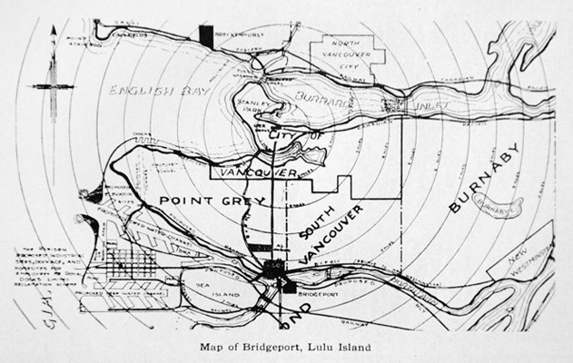
A few decades earlier, Colonel Moody, commander of the Royal Engineers, tried fruitlessly to change the name Lulu Island to Palmer Island, after one of his senior officers. As the story goes, the island got its original name, from Moody himself, after a dancer and entertainer named Lulu Sweet.
The attempt by Moody to change it is likely the result of more sober reflection as to the suitability of such a name, said Hayes. Needless to say, Lulus name was the one that stuck!
However, it wasnt all failed attempts at the beginning.
If it werent for the gold rush of 1858, Richmond wouldnt have the number system for its roads that exists today. Prior to the gold rush, Richmond, Delta, and most of the surrounding land was drawn as water on a map because it was so flat Point Roberts was thought an island.
Early colonizers realized they needed to start surveying this previously ignored territory if they wanted to encourage people to settle there.
Maps have a lot of information, but have often been overlooked by historians as a source of information, said Hayes, whose atlases have sold more than 250,000 copies worldwide. So I want to set the balance right on that.
Hayes began work on his latest atlas about 10 years ago, touring British libraries and museums, which contained archived information from when Canada was a colony.
He then conducted a grand tour of all the provinces museums, libraries and archives.
Some of these places will surprise you by the amount of information they have, he said from his White Rock home. For example, Rossland, out in the Kootenays, has a whole wealth of mining information and underground mining maps in their museum.
Hayes love for geography began as a kid when he collected stamps, leading him to pursue the subject in university.
While in Europe, he stumbled across an old map in an antique store. Surprised by some of the information he discovered, he began to research the history of it.
It then snowballed from there, he said. My love for geography combined with history meets with old maps.
More than 10 years ago, Hayes published his first atlases of the Pacific Northwest.
He released both a Canadian edition, The Historical Atlas of British Columbia and the Pacific Northwest, and an American, Historical Atlas of the Pacific Northwest.
The unexpected success of these 320 original maps prompted Hayes to continue to publish more about North America and the Arctic.
Im here to make history interesting, Hayes said. These maps are almost works of art.
Many of them are things youd frame and hang on your wall.
The 2.5-kilo atlas about British Columbia is number 13 of his collection.
When beginning work on a new atlas, Hayes determines what he wants to discuss and selects the maps that best illustrate these events.
I love the fact that I can select the images and lay out the pages, its a creative process I very much enjoy.


